Indian State And Union Territory - Maharashtra
Chief Minister: Devendra Fadnavis
Governor: Shri C. P. Radhakrishnan
Area: 3,07,713 sq. km
Capital: Mumbai
Population: 112372972
Male Population: 58361397
Female Population: 54011575
Total Literacy(%): 82.91
Male Literacy(%): 89.82
Female Literacy(%): 75.48
Sex Ratio: 925
No of District: 35
Principal Languages: Marathi
Other Languages: Marathi 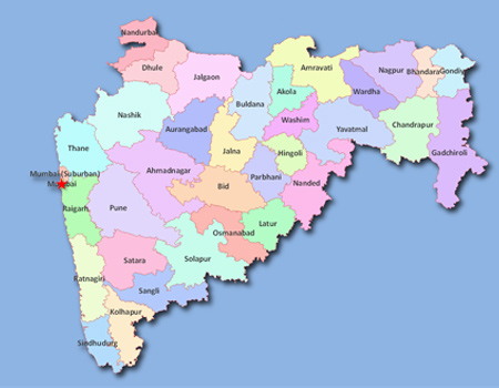
History and Geography
The first well-known rulers of Maharashtra were the Satavahanas (230 BC to 225 AD), who were the founders of Maharashtra, and have left a plethora of literary, epigraphic, artistic, and archaeological evidence. This epoch marks tremendous development in every field of human endeavour.
Then came the Vakatakas who established a pan-Indian empire. Under them Maharashtra witnessed an all-sided development in the fields of learning, arts and religion. Some of the Ajanta Caves and fresco paintings reached their pinnacle during their rule. After the Vakatakas and after a brief interlude of the Kalachuri dynasty, the most important rulers were the Chalukyas followed by the Rashtrakutas and the Yadavas apart from the Shilaharas on the coast. The Yadavas, with Marathi as their court language extended their authority over large parts of the Deccan.
While the Bahamani rule brought a degree of cohesion to the land and its culture, a uniquely homogeneous evolution of Maharashtra as an entity became a reality under the able leadership of Shivaji. Anew sense of Swaraj and nationalism was evolved by Shivaji. His noble and glorious power stalled the Mughal advances into this part of India. The Peshwas established the Maratha supremacy from the Deccan Plateau to Attack in Punjab.
Maharashtra was in the forefront during freedom struggle and it was here that the Indian National Congress was born. A galaxy of leaders from Mumbai and other cities in Maharashtra led the Congress movement under the guidance of Tilak and then Mahatma Gandhi. Maharashtra was the home of Gandhi's movement, while Sevagram was the capital of nationalistic India during the Gandhian era.
The administrative evolution of the state of Maharashtra is the outcome of the linguistic reorganisation of the States of India, effected on 1 May 1960. The State was formed by bringing together all contiguous Marathi-speaking areas, which previously belonged to four different administrative hegemonies. They were the districts between Daman and Goa that formed part of the original British Bombay Province; five districts of the Nizam's dominion of Hyderabad; eight districts in the south of the Central provinces (Madhya Pradesh) and a sizeable number of petty native-ruled state enclaves lying enclosed within the above areas, were later merged with adjoining districts. Located in the north centre of Peninsular India, with the command of the Arabian Sea through its Port of Mumbai, Maharashtra has a remarkable physical homogeneity, enforced by its underlying geology The dominant physical trait of the State is its plateau character. Maharashtra is a plateau of plateaus, its western upturned rims rising to form the Sahyadri Range parallel to the sea-coast and its slopes gently descending towards the east and south-east. Satpura ranges cover the northern part of the State, while Ajanta and Satmala ranges run through central part of State. Arabian Sea guards the western boundary of Maharashtra, while Gujarat and Madhya Pradesh are on the northern side. Chhattisgarh covers the eastern boundary of the State. Karnataka and Andhra Pradesh are on its southern side.
Agriculture
About 65 per cent of the total workers in the State depend on agriculture and allied activities. Net irrigated area in 2009-2010 was 33.21 lakh hectares respectively. Principal crops grown in the State are rice, jowar, bajra, wheat, tur, mung, urad, gram and other pulses. The State is a major producer of oil seeds. Groundnut, sunflower, soyabean are major oil seed crops. Important cash crops are cotton, sugarcane, turmeric and vegetables.
Industry
The State has been identified as the country's powerhouse and Mumbai, its capital as the centre point of India's financial and commercial markets. Industrial sector occupies a prominent position in the economy of Maharashtra. Food products, breweries, tobacco and related products, cotton textiles, textile products, paper and paper products, printing and publishing, rubber, plastic, chemical and chemical products, machinery, electrical machinery, apparatus and appliances, and transport equipment and parts contribute substantially to the industrial production in the state.
The contribution of Industries in the State in total value of output was 19 per cent while that in the gross value added was about 20 per cent during 2009-10.
Irrigation and Power
By the end of June 2005, 32 major, 186 medium and about 2,549 state sector minor irrigation projects had been completed. Another 54 major and 72 medium irrigation projects are under construction. The gross irrigated area in 2009-10 was 40.50 lakh hectares.
Maharashtra has an installed capacity of 19,816 MW as on 31st December 2011. Total power generation was 83,017 million KWH.
Transport
Roads: Total length of roads in the State as in March 2010 was 2.40 lakh km consisting of 4,376 km of national highways, 34,102 km of state highways, 49,621 km of major district roads, 46,817 km of other district roads, and 1,04,844 km of village roads.
Railways: Maharashtra has 5,983 km of railway routes which is 9.4% of total railway route in the country
Aviation: There are 3 International and 5 Domestic Airports in the State. To reduce congestion in Mumbai International Airport additional Airport has been proposed at Navi Mumbai.
Ports: Mumbai is a major port. There are two major and 48 notified minor ports in the State.
Tourist Centres
 Some important tourist centres are : Ajanta, Ellora, Elephanta, Kanheri and Karla caves, Mahabaleshwar, Matheran and Panchgani, Jawhar, Malshej ghat, Amboli, Chikaldara, Panhala Hill stations and religious places at Pandharpur, Nasik, Shirdi, Nanded, Audha Nagnath, Trimbakeshwar, Tuljapur, Ganpatipule, Bhimashanker, Harihareshwar, Shegaon, Kolhapur, Jejuri and Ambajogai.
Career Scope in Interior Design
Interior design is a fun and creative field. It mixes art and practicality to make spaces look good and work well. With more people wanting great places to live and work, the need for skilled interior designers is rising. Let’s look at what it takes to have a career in interior design, including nee →
Commonwealth of Independent States (CIS)
Foundation Date: December 8, 1991 Headquarters: The Republic of Belarus Executive Secretaries: Sergei Lebedev Member Countries: 12 Commonwealth of Independent States (CIS) was established on December 8, 1991, and the leaders of the Republic of Belarus, the Russian Federation, and Ukraine signed an a →
What is Bitcoin?
In 2009, an unknown programmer by the name of Satoshi Nakamoto put forward a whitepaper that proposed a creation of new form of digital currency - cryptocurrency. Cryptocurrency functions the same way as regular currencies do in that its used as a means of exchange, unit of account and a store of va →
Food Safety and Standards Authority of India (FSSAI)
Headquarter: New Delhi Function and Objective of the Organization: The Food Safety and Standards Authority of India (FSSAI)has been established under Food Safety and Standards Act, 2006 which consolidates various acts & orders that have hitherto handled food-related issues in various Ministries →
Contribute to our Site
If you contribute your content to our site. Please mail us your content to editor@onlinegk.net